Updated on: April 13, 2026 / 11:52 AM EDT / CBS News
Guam and other U.S.
island territories in the western Pacific Ocean on Monday braced for the most powerful storm of the year so far, which could bring destructive winds and widespread flooding over the next 48 hours, forecasts show.
The typhoon's maximum sustained winds stabilized at 175 mph as the massive storm approached the island chain, after peaking at 180 mph on Sunday.
This is the strongest storm to develop in 2026, behind typhoons Narelle and Dudzai, which respectively peaked at 149 and 147 mph, said CBS News meteorologist Nikki Nolan.
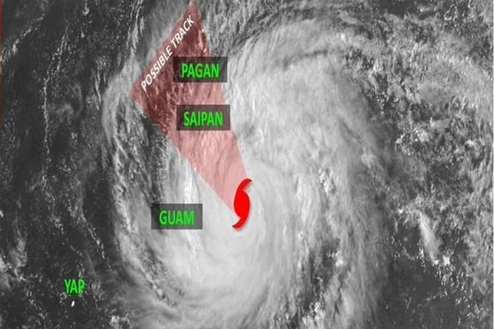
Monday, April 13, 2026.
Valid at 6:37 PM ChST Typhoon Warning: Rota, Tinian, Saipan Tropical Storm Warning: Guam, Pagan, Alamagan Typhoon Watch: Guam Tropical Storm Watch: Agrihan For the latest forecast and information, visit https://t.co/kUCuTWXo6w pic.twitter.com/JGt0GC4XMv — NWS Guam 🇬🇺 (@NWSGuam) April 13, 2026
In the Southwest Pacific, "typhoon" is the term used to describe a tropical storm that forecasters would call a hurricane in the U.S.
They're just two different names for the same kind of weather system.
Atlantic hurricanes are ranked on a scale of 1 to 5 that categorizes them by their capacity to cause damage.
The highest ranking, Category 5, is assigned to storms that have sustained winds of at least 157 mph.
In the Pacific, a typhoon of that intensity is called a "super typhoon."
Although Sinlaku is expected to weaken before crossing the Marianas near the neighboring islands of Tinian and Sapian later on Tuesday, forecasters say the system could still arrive with winds equivalent to those of a Category 4 or 5 storm.
Residents of islands in or near the typhoon's path have been advised to prepare for thunderstorms and heavy rain, potentially causing flooding, in addition to extremely strong winds.
As of the weather service's latest update, typhoon-force winds extended outward for up to 80 miles from Sinlaku's center, and tropical-storm-force winds extended outward for up to 275 miles.
A typhoon warning was in place for the Marianas islands of Rota, Tinian and Saipan, while tropical storm warnings were in place for Guam as well as the islands of Pagan and Alamagan, and a tropical storm watch was in place for the island of Agrihan, according to the weather service.
A typhoon watch was also effective for Guam, where officials warned people to remain indoors and out of the water.
"While the threat of typhoon-force winds has significantly diminished, this remains a serious weather event," Guam's Joint Information Center said in an advisory .
The advisory noted that Sinlaku could bring tropical-storm-force winds to Guam, ranging from 39 to 73 mph, for an extended period of time between Monday night and Wednesday.
Related Stories


Source: This article was originally published by CBS News
Read Full Original Article →
Comments (0)
No comments yet. Be the first to comment!
Leave a Comment